
At the surface, a site may consist of woodland, a slope and scattered rock outcrops. For a designer or contractor, the question lies beneath: where is the rock mass relatively continuous, and where might weakened ground, karst cavities or collapse zones affect the project?
An example from our work in Austria illustrates how ground-penetrating radar can complement surface observations and information from individual boreholes.
Why Karst Creates Uncertainty
In limestone and dolomite, circulating water gradually enlarges fractures and develops underground drainage pathways. Cavities may contain air, water or loose sediment and rock fragments. Conditions can vary considerably over short distances, making it difficult to extend the findings of one borehole across an entire site. Background on karst formation — USGS.
For a construction project, the position and extent of these features matter in relation to the proposed foundations, structure or route. Understanding that relationship helps determine where additional investigation will be most useful.
What the Austrian Profiles Show
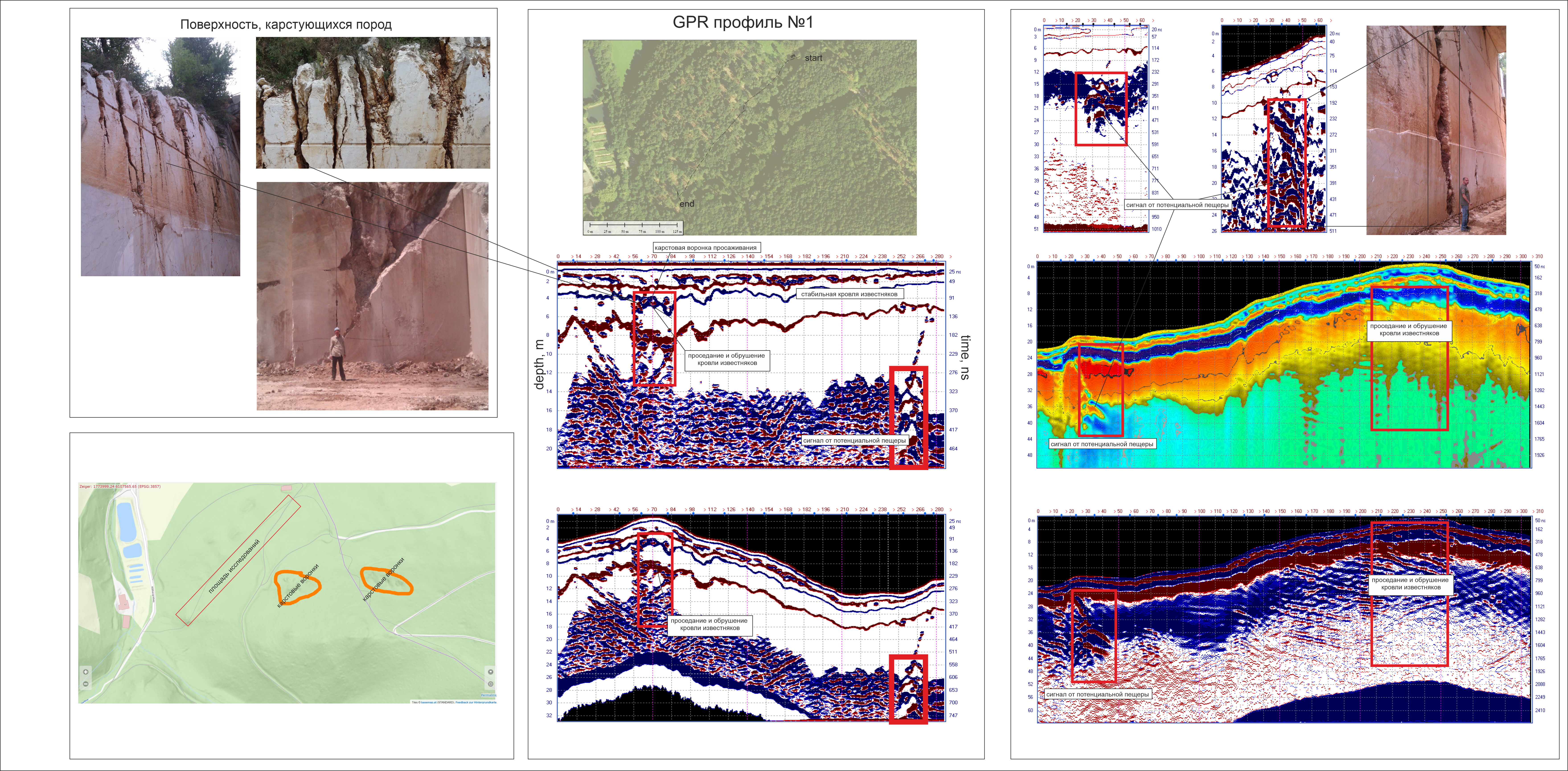
The project illustrations bring together the site layout, survey alignment and radar sections. One processing view incorporates topographic correction, allowing reflecting boundaries to be compared in their spatial context along the slope.
The sections show areas with relatively continuous boundaries alongside zones where the reflection pattern changes. Some of these zones were interpreted as possible subsidence or collapse of the rock roof. Other responses were marked as indications of a potential cavity.
These annotations form a working geological interpretation. Verification boreholes, accessible exposures and other site evidence help establish what is producing the observed response.
Why We Compare Several Interpretations
A separate comparative illustration presents the same radar profile with alternative interpretations. The observed pattern is considered in terms of collapse, a karst conduit, fracturing, a fault or a cavity.
The practical question is which additional observations can distinguish between these explanations. Adjacent and intersecting profiles, terrain, rock exposures and direct investigation results all contribute to that assessment.
Interpretation uncertainty and site-dependent investigation depth are significant considerations when using GPR. Overview of the method — US EPA.
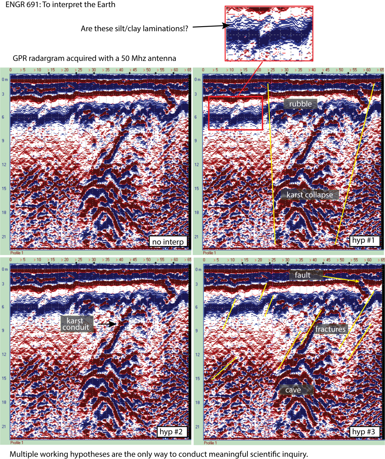
The German-labelled illustrations were localised with ImageGen and are intended to explain the figures. The linked originals remain the reference for scientific details and numerical readings.
What Makes the Results Useful to a Client?
For subsequent design work, useful outputs include the mapped positions of anomalous zones, their relationship between survey profiles, and a list of locations for priority verification. A report should clearly distinguish measured responses, geological interpretation and independently confirmed ground conditions.
Geophysical investigation can support foundation and piling projects, road and utility route planning, and assessments of sites showing signs of subsidence. The method, survey spacing and achievable investigation depth are selected according to the project objectives and ground conditions. Geotechnical parameters and design decisions require the appropriate engineering investigations.
Planning Work on a Karst Site?
Send us the site location, a layout of the proposed structure or route, and any available geological information. We will review what geophysics could contribute, propose a survey scope and discuss how the results can be verified.