Exploration
In the mining resource sector, we offer exploration and geophysical prospecting services applied to metallic and non-metallic deposits, performing a detailed mapping of the deposit for its quantification.
In the mining resource sector, we offer exploration and geophysical prospecting services applied to metallic and non-metallic deposits, performing a detailed mapping of the deposit for its quantification.
We run geophysical surveys that produce drill-ready targets — not "interesting anomalies". Structural controls, conductive ore body signatures, and depth estimates delivered in a single field campaign. Operating in greenstone belts and complex geological settings since 2006.
The Loza system captures two independent responses from a single survey pass. This is not a limitation — it is the methodology.
Resolves lithological contacts, fault planes, shear zone geometry, fold axes, and intrusive boundaries — the structural framework that controls where ore localizes.
Identifies conductive bodies in the subsurface — sulfide mineralization, graphitic horizons, water-bearing zones, and alteration products with elevated conductivity.
The dual-regime approach is most effective where structural controls and conductive mineralization co-exist — which describes the majority of economic gold and base metal systems.
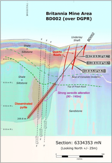
Shear-hosted, quartz vein, and disseminated gold in greenstone belts. The Loza system maps the controlling structure and detects sulfidic envelopes simultaneously.
Massive sulfide bodies, copper-bearing zones, and VMS systems. High conductivity contrast makes these excellent targets for late-time diffusion response.
Regional fault systems, shear zones, and lithological contacts that host multiple mineralized shoots along strike.
Basement topography, paleochannel positions, and weathered saprolite profiles that concentrate placer gold. Bedrock depth mapping along drainage corridors.
Pipe geometry, intrusive contacts, and associated alteration halos. Structural context for pipe emplacement controls.
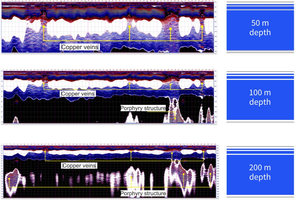
Alteration zone mapping, structural feeders, and depth to mineralized core in porphyry copper-gold and epithermal gold systems.
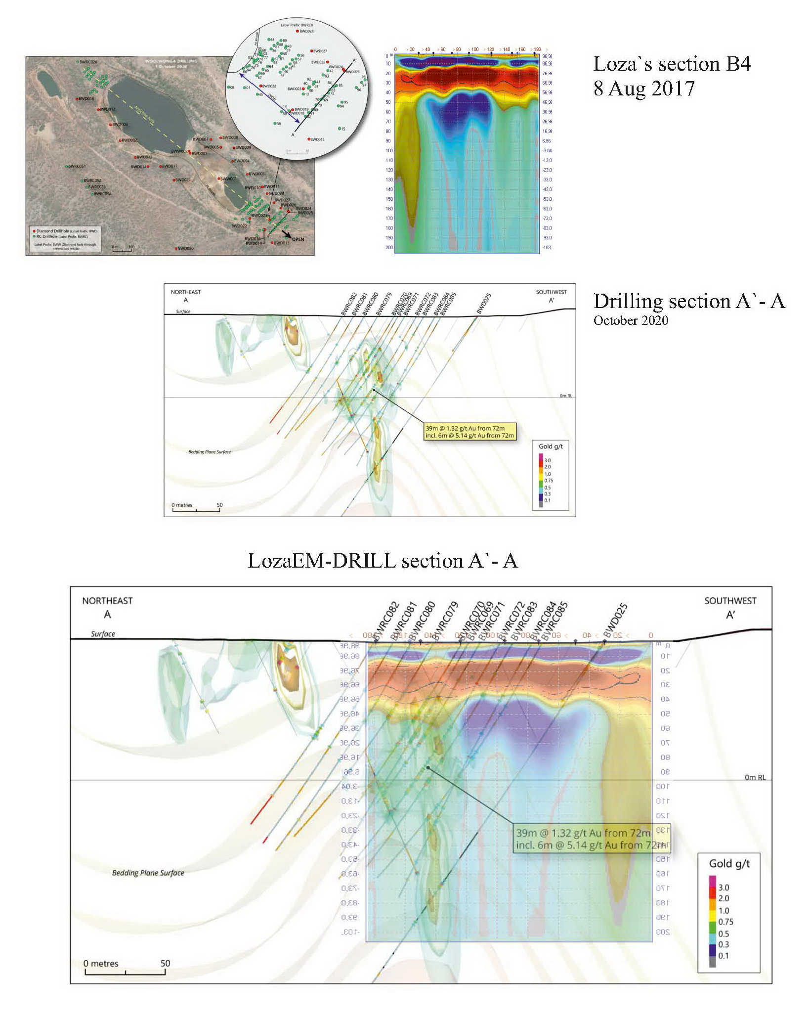
This case illustrates what the dual-regime interpretation delivers before a single drill hole is collared.
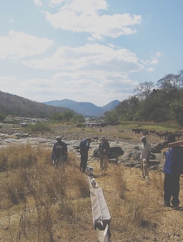
Greenstone belt target, Zimbabwe. The client had identified a structural corridor from regional mapping but had no geophysical data to constrain drill collars or estimate mineralization depth.
A series of Loza profiles were acquired across the target structure. Early-time response defined the shear zone geometry and a subsidiary fault splay. Late-time diffusion response detected a conductive body at depth coinciding with the structural intersection — a classic trap geometry for orogenic gold.
The intersection followed the structural corridor identified in the geophysical section. The conductive signature corresponded to sulfide-bearing mineralization within the shear zone.
Every deliverable is tied to a decision — not produced to fill a report template.
2D structural profiles and conductivity proxy sections along each survey line. Annotated with interpreted geological contacts, anomalies, and depth estimates.
Plan-view maps of conductive anomaly positions across the survey grid, overlaid on available geological and topographic data.
Ranked target list with coordinates, depth estimates, and structural context. Each target includes the rationale for prioritization.
Suggested collar positions, dip/azimuth, and target depth for each priority target. Integrated with available geological mapping and previous drilling if provided.
Survey results correlated with existing geological data — outcrop mapping, soil sampling, previous drill results — to place geophysics in context.
Full technical report suitable for investor presentation, regulatory submission, or internal program review. Includes methodology, data quality, and limitations.
In resistive basement geology with conductive targets (the typical greenstone belt setting), effective investigation depth is 50–200 m. In conductive overburden — thick laterite, saline soils, or clay-rich saprolite — depth is reduced and we assess this during scoping. We do not advertise a fixed depth figure: the honest answer is site-dependent.
Laterite is conductive and attenuates the signal, reducing effective depth. However, the late-time diffusion response is still capable of detecting strong conductors beneath moderate laterite cover. We have successfully targeted sulfide bodies under 15–25 m of laterite in West African settings. Thick (40+ m) laterite significantly limits the method.
Both generate conductive responses and cannot be separated by geophysics alone. However, the structural context — position relative to shear zones, fold axes, and lithological contacts — allows geological interpretation to assess which conductor type is more likely. We always deliver structural + conductivity together for this reason.
Reconnaissance: 200–400 m line spacing for target identification over large areas. Detail / pre-drill: 50–100 m spacing for anomaly geometry and drill collar positioning. Grid spacing is adapted to target size, expected depth, and budget constraints. We recommend the appropriate geometry during scoping.
Typical survey productivity is 3–10 line-km per day depending on terrain, vegetation, and profile spacing. This is comparable to ground IP and faster than most TEM configurations for the same target depth. The system is vehicle-deployable and operable with a small crew in remote conditions.
Yes. If you have existing Loza data that was processed with older methods or basic processing, we can reprocess using current AU Studio attribute extraction — including dual-regime separation, tau-gradient analysis, and 2D tomographic sections. Contact us with the data format and acquisition parameters.
Field experience across major mineralized terranes on five continents.
Zimbabwe greenstone belts (Midlands, Masvingo), Tanzania (Lake Victoria goldfields, Lupa), Zambia (Copperbelt margins), Mozambique, Malawi.
Ghana (Ashanti belt), Senegal, Mali (Kéniéba), Burkina Faso, Guinea, Côte d'Ivoire — Birimian greenstone targets.
Kazakhstan, Uzbekistan, Kyrgyzstan — Tian Shan and Altai gold belts, porphyry copper targets, fold-and-thrust settings.
Peru (Andes porphyry and epithermal), Chile (Atacama copper), Brazil (Quadrilátero Ferrífero), Guyana Shield targets.
Democratic Republic of Congo — copper-cobalt belt, gold targets, Kibaran and Lufilian arc settings.
Turkey, Iran, Philippines, Indonesia, Australia, and Europe — full project list on request.
Identify vein directions and estimate the dimensions without limitations by the type of host rock.
Delineate mineralized contacts, on different types of deposits such as Skarns, VHMS, Porphyries and disseminated mineralisation structurally or stratigraphically controlled.
Generate geological sections and models of the mineralized body.
Determine the stronger of the most productive horizon of multiple sites.
Identify locate more suitable areas for the establishment of limestone quarries, clays, sands or plasters.
Performs reserve volume calculation.
Generate 2D sections and 3D models.
Quartz vein
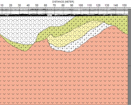
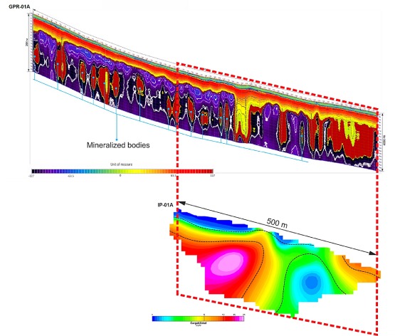
Combining methods for calculating the reserves of a copper deposit.
1.Ground Penetrating Radar (GPR)
2. Induced Polarization (IP)
Move the slider
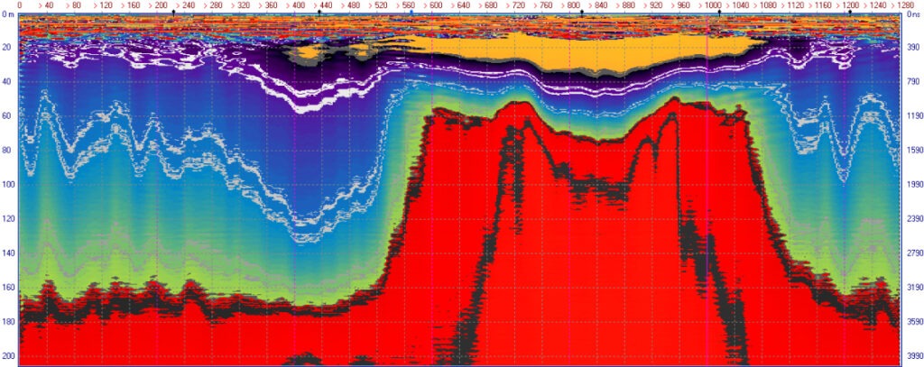
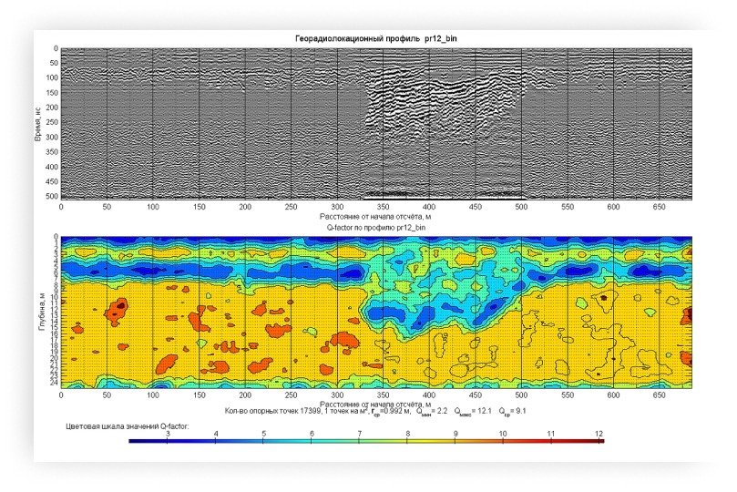
Conducting geological exploration of the chromite ore deposit in Kazakhstan. The data of georadar sounding are presented in two processing options.
A representation with the selection of minima and maxima with Low-Frequency and High-frequency filters and in the amplitude representation with Low-Frequency and High-Frequency filters.
On the georadar section in two processing options, the geological structure of the ore body (70 – 240 meters) is contrasted. The georadar survey made it possible to detect a linearly extended object in the ore body array. This is an old abandoned mine with a depth of the upper arch of 50 meters. The data of the testing wells confirmed the presence of the chromite ore body and the old abandoned mine.
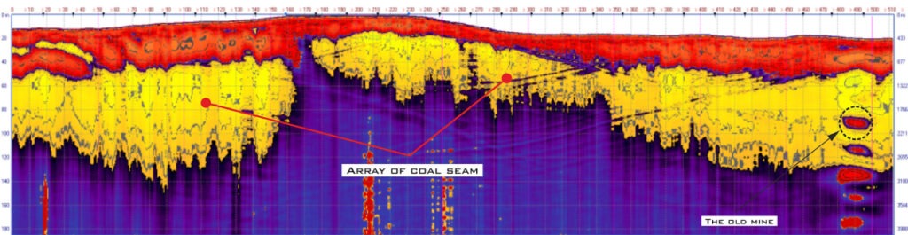
The georadar profile is made in the process of exploration
of a coal deposit in the north of Turkey.
On the georadar section, an array of coal seams is contrasted. The georadar survey made it possible to detect
a linearly extended object in the coal bed. This is an old abandoned mine with a depth of the upper arch – 60 meters.
The data of the testing wells confirmed the presence of coal and the old abandoned mine.
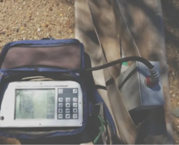
The survey was performed by the Loza-N georadar with antennas of 6 meters (25 MHz) and a 21 kV transmitter.
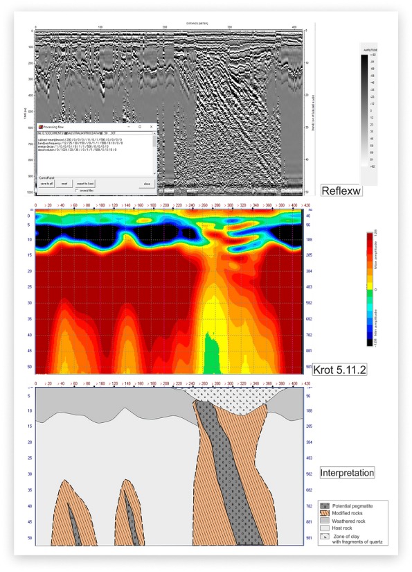
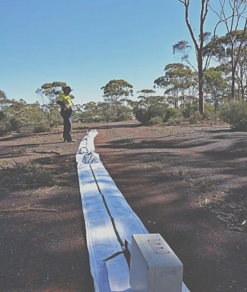
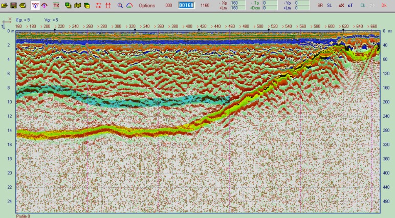
The georadar profile is made in the process of geological prospecting for the purpose of mapping the boundaries of a kimberlite pipe in Australia.
On the georadar section, the boundaries of the investigated body are clearly traced.
The survey was performed by the Loza-N georadar with antennas of 6 meters (25 MHz) and a transmitter with a pulse power of 20 MW.
Australia, 2016
South Africa, 2015
Australia, 2017
GPR profile was performed in the process of exploration to identify pegmatite dikes.
Over years our specialists have successfully used a new technique for the detection of such bodies.
The survey was conducted with GPR Loza-N antennas of 6 meters (25 MHz) and the transmitter pulse power of 20 MW.