Hydrogeology & Groundwater Survey
GPR for hydrogeological studies
GPR for hydrogeological studies
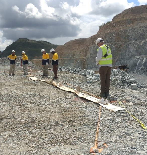
We locate productive groundwater zones before drilling — reducing dry-hole risk and identifying the most likely well positions in fractured basement, sedimentary, and karst settings. The Loza electromagnetic system detects water-bearing structures at depths conventional methods miss.
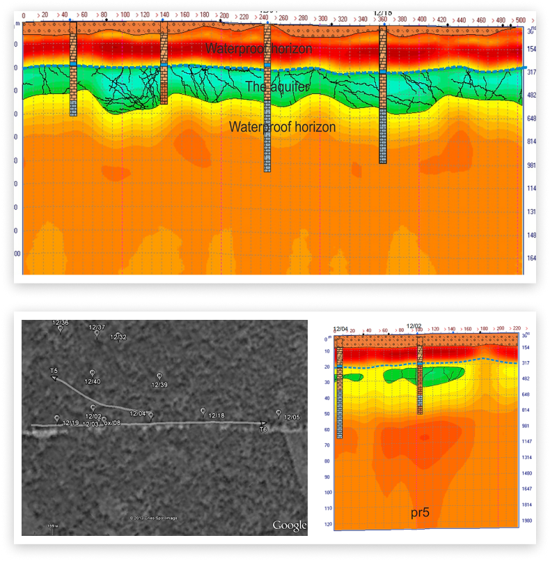
Underground water flows and reservoir zones
Hydrogeological characterization of the subsurface
Areas of greatest aquifer capacity and permeability
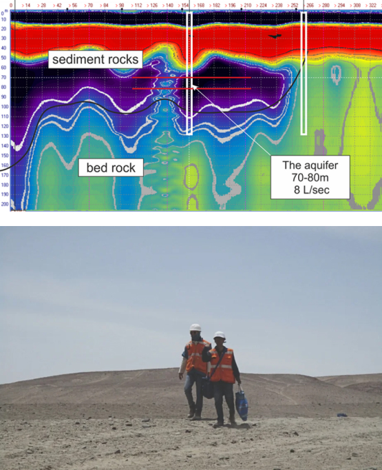
Structural environment — faults, shear zones, fracture systems
Buried paleochannels and ancient river valleys
Buried paleochannels are among the most productive sources of fresh groundwater. These ancient valleys occur at varying depths beneath different sediment sequences. Water accumulates in permeable units — sands, gravels, limestones — confined by impermeable layers above and below (confined aquifer geometry).
The Loza electromagnetic system detects faults and shear zones — which are primary pathways for groundwater. River valleys frequently follow tectonic fault systems, creating a direct structural connection between the fault and the productive aquifer. This connection is visible in electromagnetic sections as a combination of structural response and conductivity anomaly.
Water has exceptionally high dielectric permittivity due to the dipole nature of water molecules:
This contrast makes water-bearing zones stand out clearly in electromagnetic sections. Note: high permittivity is lost when water freezes — ice behaves differently from liquid water.
The effective permittivity of a water-bearing rock system follows the mixing law (Birschak et al. 1974):
ε = φSwεwater + φ(1−Sw)εair + (1−φ)εmatrix
Higher saturation and porosity produce stronger electromagnetic response — making productive aquifer zones detectable at depth.
1. Reflection: The water table presents a strong electromagnetic reflection boundary due to the high permittivity contrast between the saturated and unsaturated zones.
2. Velocity reduction: Wave velocity decreases in the saturated zone because V = c/√ε. Higher water content → lower velocity → visible as time pull-down in the section.
3. Conductivity response: Saline or mineralized water produces a conductivity anomaly detectable in the late-time diffusion regime.
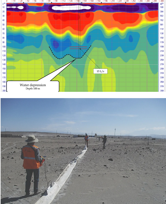
Water table clearly resolved as a reflection boundary. The transition from unsaturated to saturated zone is visible as a continuous high-amplitude interface across the profile.
Changes in wave pattern within the aquifer and below confirm the presence of water-bearing fracture zones at depth.
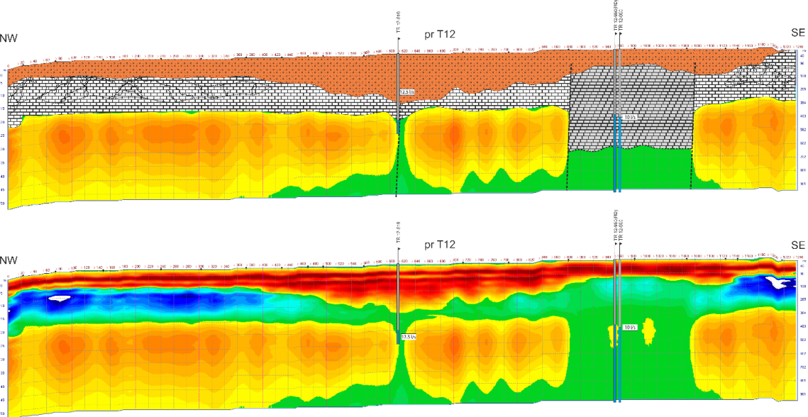
Drilled based on electromagnetic profile 12 — anomaly interpreted as a fault/shear zone approximately 200 m wide, confirmed by geological map showing a NE-striking shear zone. Drilled to 60 m depth through dolomites and limestone. Large cavity intersected at 40–60 m bgl. Main water strike at 27 m bgl in a fractured zone above the cavity.
Replacement borehole drilled 10 m north. Final depth 60 m through dolomitic sedimentary rock and limestone. Main water strike at 25 m bgl within a fractured zone. Borehole construction not completed due to surface blowout during drilling.
Drilled based on a vertical anomaly on electromagnetic profile 12 — interpreted as the same NE shear zone system. Drilled to 36 m through dolomitic siltstone, shale, and limestone. Main water strike in a highly fractured zone at 25 m bgl.
In resistive basement geology, effective investigation depth for groundwater targets reaches 50–150 m. In more conductive settings — laterite, saline soils, clay-rich sediments — depth is reduced. We assess expected depth range during project scoping based on regional geology and available background data.
Yes. Fractured basement aquifers are one of the primary targets for the Loza electromagnetic system. Fracture zones, faults, and shear zones produce a detectable electromagnetic response due to increased water content and conductivity contrast. The structural position of fractures is mapped in the early-time wave response, while water-bearing zones are confirmed in the late-time diffusion response.
Traditional methods — resistivity sounding, seismic refraction, geological mapping — each capture one aspect of the subsurface. The Loza electromagnetic system captures structural geometry and conductivity response simultaneously, in a single survey pass, without requiring electrode planting or heavy logistics. This reduces survey time and cost while providing comparable or better depth resolution for fractured aquifer targets.
Saline water has much higher conductivity than fresh water and produces a stronger late-time diffusion response. This contrast can be used to identify saline intrusion boundaries or contamination plumes. Direct discrimination between fresh and saline water requires calibration against existing borehole data or chemical analysis.
Standard deliverables include: processed electromagnetic sections with aquifer interpretation, plan-view anomaly maps with recommended well positions, depth estimates for target water-bearing zones, and a technical report with borehole siting recommendations and geological context. Reports are formatted for hydrogeological, agricultural, or engineering use as required.