Geophysical & Geological Consulting
Exploration Consulting — From Raw Data to Decisions You Can Act On
Sometimes you don't need another survey. You need someone to connect the dots: geology, geophysics, mining constraints, and the reality of budget and logistics. We integrate Loza electromagnetic data with geological mapping, drilling results, and engineering context — and deliver a plan, not a report.
Geological Exploration Consulting
Full-cycle geological support for exploration programs — from target generation to drill result interpretation. We work with junior explorers and major companies, adapting scope to budget and project stage.
What we provide
- Exploration program planning within budget and timeline constraints
- Logistical planning and support — including remote camp establishment
- Target generation and prioritization for diamonds, gold, copper, lead/zinc, tungsten, antimony, iron ore
- Full interpretation and presentation of results with actionable recommendations
- Mine planning and review of existing mining engineering projects
- GIS and geological modeling
Mining & Civil Engineering Consulting
Mining and civil engineering support for projects at any stage — from early planning through to supervision. We work with qualified professionals across disciplines to provide technically sound recommendations.
How we can help
- Consultation at early project stages and through to supervision
- Marine geology consulting
- Full interpretation and presentation of results with recommendations
- Mine planning and review of existing mining or civil engineering projects
- Open pit and underground studies
- GIS and geological modeling
Integrated Consulting: Geology + Geophysics + Engineering
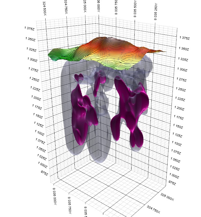
We build one consistent interpretation from all available data — geology, Loza electromagnetic sections, drilling, mapping, sampling — and resolve conflicts rather than ignoring them. The output is a prioritized plan with clear next steps.What we do
- Geological + geophysical consulting to support exploration and evaluation programs
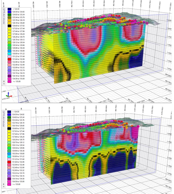
- Data analysis: Loza electromagnetic, magnetics, TEM/EM, geology logs, mapping, sampling — whatever you have
- Correlation: geophysics ↔ geology ↔ drilling ↔ mapping into one consistent model
- Targeting & prioritization: where to drill, where to trench, where not to waste budget
- Reporting: clear deliverables for field teams, management, and investors
Technical scope
- Mineral Exploration — target generation and drill prioritization
- Mining Project Evaluation — resource and reserve context
- Geology & Resource Assessment
- Mine Engineering & Geotechnics
- Mine Waste Management
- Extractive Metallurgy & Mineral Processing
- NI 43-101 / JORC support — technical sections and sanity checks
Note: you don't need "perfect data" to start. If there is information — we can use it.
The point is to turn it into decisions.
How geology and geophysics integrate — and why it reduces cost
Your objective
Exploration / evaluation / mine planning / risk reduction
Geology branch
Mapping, lithology, alteration, structure, sampling, drill logs, domaining
What we extract
Controls, host units, structural framework — "where it should be"
Geophysics branch
Loza electromagnetic, TEM/EM, magnetics, resistivity, gravity — depending on the case
What we extract
Anomalies, boundaries, conductive zones, depth trends, continuity along profile
Engineering branch
Geotechnics, mine design constraints, processing reality, waste, compliance
What we extract
Risks, practical constraints — "what can actually be done"
Integration
One model: geology + geophysics + constraints. Conflicts resolved, not ignored.
Deliverables
Target list · drill/trench plan · maps and sections · correlation notes · risk flags · report-ready material
Next-step plan
What to do next week, next month — and what to stop doing immediately
Interpretation training & data reprocessing
If your team has existing electromagnetic data that was processed with older methods, or needs to build internal interpretation capability — we offer both reprocessing and training.
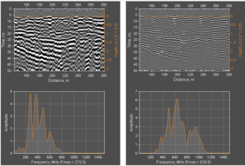
- Interpretation of data from any Loza electromagnetic system configuration
- Theoretical course — remote delivery available
- Practical field course using Loza-V and Loza-N systems (worldwide travel available)
- Interpretation training on your own datasets — remote delivery available
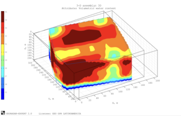
- 2D/3D section construction and attribute analysis based on electromagnetic data

Consulting — Frequently Asked Questions
Can you work with data collected by other geophysical methods — not just Loza?
Yes. We work with any available geophysical dataset — magnetics, IP, gravity, airborne EM, conventional GPR, TEM/TDEM — as well as geological logs, mapping, sampling, and drill results. The goal is integration, not replacement.
What if our existing data is incomplete or poorly documented?
Incomplete data is the norm, not the exception. We assess what is usable, identify gaps, and recommend the minimum additional work needed to support a decision. We do not require "perfect" datasets to start.
Can you support NI 43-101 or JORC technical reports?
Yes — we provide technical inputs, geological and geophysical sections, target documentation, and sanity checks for compliance reporting. We do not act as Qualified Person (QP) but work directly with your QP to supply technically sound material.
Do you offer remote consulting or is field presence required?
Both options are available. Data review, interpretation, reporting, and training can all be delivered remotely. Field presence is available worldwide for projects that require on-site geological or geophysical work.
How long does a typical consulting engagement take?
A focused data review and targeting recommendation typically takes 1–3 weeks depending on dataset size and complexity. Full program support — from scoping through to final report — is scoped per project.
Company Presentation